Study on Resilient Infrastructure Recommendations Informs Real-World Implementation
 As climate change continues to drive sea level rise, many coastal regions are being forced to reconsider their typical development practices and adopt new standards to improve resiliency. In November 2018, Virginia Governor Ralph Northam issued an executive order with directives to standardize and set minimum building requirements for all state-owned buildings. Clark Nexsen and Old Dominion University tested these new recommendations with a study examining 12 buildings on ODU’s campus.
w
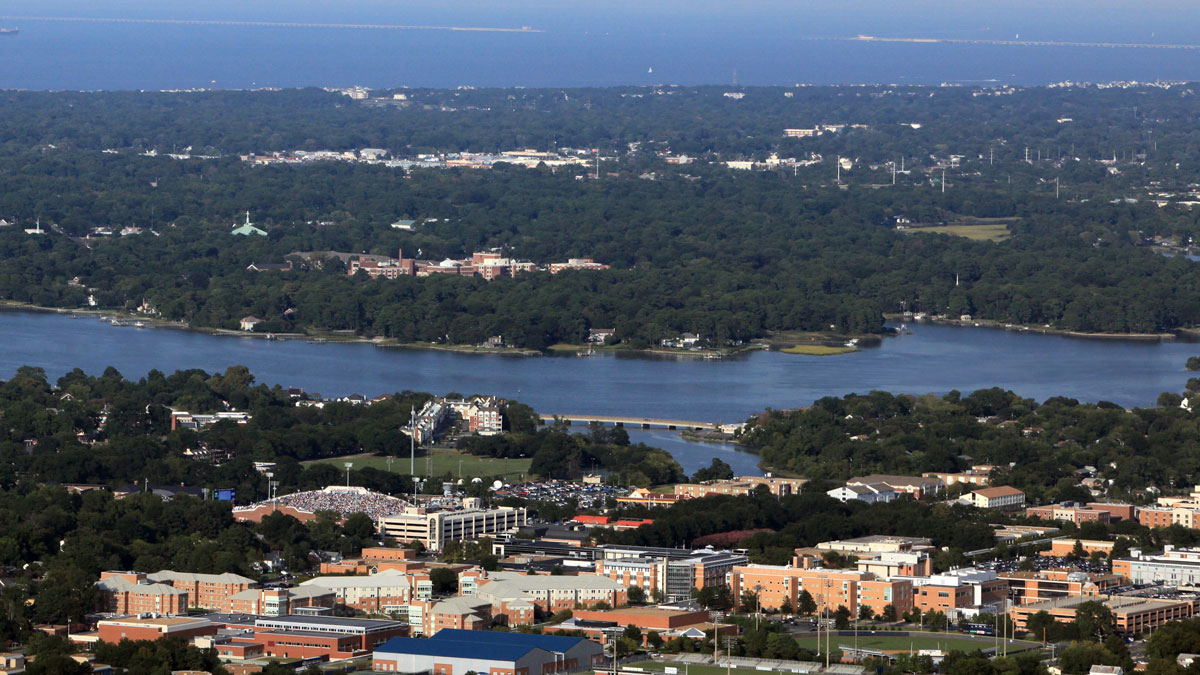
At the mouth of the James River with a maximum elevation of less than seven feet above sea level, Old Dominion University is at a high risk for climate change-related flooding from virtually all sides. The campus is bounded by the Elizabeth River to the south and west, the James River to the northwest, and the Chesapeake Bay to the northeast. Model projections anticipate that rising seas, subsidence, and increased precipitation will only continue to increase flooding and storm events in the region.
Factors like these contributed to issuing Executive Order 24, ‘Increasing Virginia’s Resilience to Sea Level Rise and Natural Hazards.’ To stay ahead of the curve, the legislation provides detailed steps to building flood resilient infrastructure in coastal Virginia.
The Goal: Develop A Methodology for Implementing Resiliency Recommendations
Clark Nexsen collaborated with ODU to evaluate and report on the recommendations contained in the ‘Recommendations for Freeboard Standards for State-Owned Buildings in the Commonwealth of Virginia’ from the Commonwealth Center for Recurrent Flooding Resiliency (CCRFR). The overall objective of the study was to develop a standardized methodology for implementation of the CCRFR recommendations and to contrast that against the current standard from the American Society of Civil Engineers (ASCE) Standard 24-14, Flood Resistant Design and Construction, and ASCE Standard 24-14, Flood Resistant Design and Construction including the future impact of sea level rise. By the end of the study, the project team had developed methodologies that demonstrated the complex relationships and various infrastructure components affected by recurrent flooding and sea level rise. In a nutshell, we found that to develop a project, you had to identify the location of the 100- and 500-year flood plain limits (easier said than done) and what the level of the water would be to determine the finished floor elevation. These data points impact substantial aspects of building function, from the equipment servicing the building to how to access the building in the future. The findings of our study ultimately resulted in several refinements and clarifications to CCRFR’s report and key recommendations to the Governor.
By the end of the study, the project team had developed methodologies that demonstrated the complex relationships and various infrastructure components affected by recurrent flooding and sea level rise.
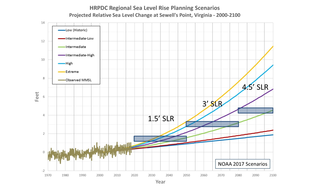
Given that all new construction underway today could extend into 2070 (50-year building life) and potentially beyond, it was necessary to consider various National Oceanic and Atmospheric Administration (NOAA) climate prediction scenarios. For example, the NOAA 2017 Intermediate curve is a potential target for infrastructure that can tolerate moderate flooding. Similarly, flooding intolerant infrastructure should be based on the higher curves. Buildings are rarely designed to withstand flooding and, based on this guidance, the NOAA 2017 Intermediate-High curve was adopted for developing freeboard standards for state-owned buildings. Using the NOAA 2017 Intermediate or Intermediate-Low scenario curves would represent a higher tolerance to risk, while using the High or Extreme scenario curves would represent a lower tolerance to risk.
Another factor in the study involved local standards: recently, Hampton Roads localities adopted standards that require using 1.5 feet of relative sea level rise above the current mean higher high water (MHHW) for near-term planning (2020-2050), 3 feet of relative sea level rise above current MHHW for medium-term planning (2050-2080), and 4.5 feet of relative sea level rise above MHHW for long-term planning (2080-2100).
 The Outcome: Study Offers Key Insights to Improve Implementation
The first step in the study focused on a rapid assessment of approximately 54 buildings to identify good candidates to evaluate the new recommendations. Ultimately, 12 facilities that represent a broad cross section of building types and existing flood zones were selected for a more comprehensive assessment. The team determined the existing buildings’ first floor elevations, year of construction, and square footage, and identified any critical infrastructure (generator, electrical transformers, etc.) – all of which could play a role in the building’s resiliency.
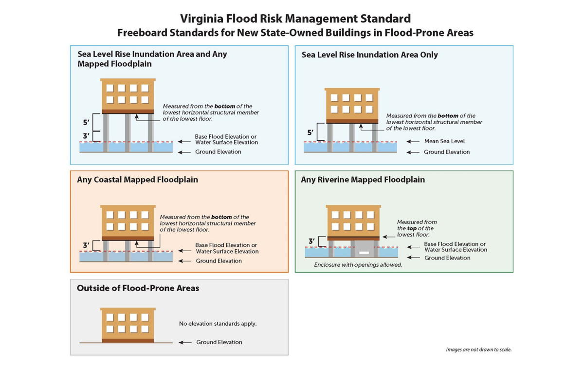
The next step in the process established the existing building’s location within the FEMA 100-year and 500-year flood zones. To contrast the different standards, the team calculated the required Minimum Base Floor Elevation (MBFE) using three methods: ‘Recommendations for Freeboard for State-Owned Buildings’, ASCE 24-14, and ASCE 24-14 accounting for future climate changes. The evaluation determined the MBFE for all buildings in the study under the hypothetical pretense they would be replaced at the same site and footprint.
By conducting the evaluation and determining the assumptions to complete it, the ODU and Clark Nexsen teams identified specific areas within the recommendations that would benefit from clarification. To support ease of implementation, the study recommended clarifying the proposed procedures for calculating the MBFE within the ‘Recommendations for Freeboard Standards for State-Owned Buildings’ before the recommendations were released by the Governor’s office.
From Analysis to Action
Coming full circle from analysis to action, our collaborative study with ODU was central to informing the new standards recently signed into law by Governor Northam as Executive Order (EO-45). EO–45 announced the country’s strongest flood protections for state-owned property to safeguard against the impacts of climate change. “It is simply common sense to protect against the risk of flooding, because climate change is driving sea levels higher and making storms more intense,” said Governor Northam. “Flooding remains the most common and costly natural disaster in Virginia and in the United States, and our state government is getting prepared. These standards will protect taxpayers by establishing critical protections for new state-owned property.”
 “Executive Order Forty-Five is a critical component of the Coastal Resilience Master Plan that we are working to complete,” said Rear Admiral (Retired) Ann C. Phillips, Special Assistant to the Governor for Coastal Adaptation and Protection. “This Order sets forth a necessary foundation as we finalize the first version of that plan in the months ahead.”
The new executive order creates the Virginia Flood Risk Management Standard to improve flood protection in flood prone areas across the state, further encouraging smart and resilient construction of state buildings and establishing a “freeboard” standard that increases protection of state-owned buildings in coastal and riverine floodplains. A first of its kind for any state, the standard incorporates science-based sea level rise projections that NOAA has developed and adopted. Under the order, state-owned buildings must be built to certain elevation standards to protect them from flooding. The new standards will apply to all state-owned buildings authorized for construction after January 1, 2021.
Chris Stone, PE, F.NSPE, F.ASCE, LEED AP is a senior principal at Clark Nexsen with more than 40 years of experience in design and management. He is passionate about sustainability and resilient design, with a focus on resilient infrastructure and its impact on the urban setting. To connect with Chris, please email cstone@clarknexsen.com.
